


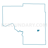
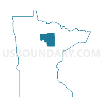
Marble Voting District, Itasca County, Minnesota
About
Outline

Summary
| Unique Area Identifier | 602635 |
| Name | Marble Voting District |
| County | Itasca County |
| State | Minnesota |
| Area (square miles) | 4.45 |
| Land Area (square miles) | 4.35 |
| Water Area (square miles) | 0.10 |
| % of Land Area | 97.74 |
| % of Water Area | 2.26 |
| Latitude of the Internal Point | 47.32809010 |
| Longtitude of the Internal Point | -93.29565220 |
Maps

Graphs
Select a template below for downloading or customizing gragh for Marble Voting District, Itasca County, Minnesota


Neighbors
Neighoring Voting District (by Name) Neighboring Voting District on the Map
- Calumet Voting District, Itasca County, MN
- Greenway Twp. P-1, Itasca County, MN
- Greenway Twp. P-2, Itasca County, MN
- Greenway Twp. P-3, Itasca County, MN
- Iron Range Twp. Voting District, Itasca County, MN
- Taconite Voting District, Itasca County, MN